Африка
Содержание:
Maps of Africa
Africa, the planet’s 2nd largest continent and the second most-populous continent (after Asia) includes (54) individual countries, and Western Sahara, a member state of the African Union whose statehood is disputed by Morocco. Note that South Sudan is the continent’s newest country.
With a 2011 population of 1,032,532,974, it accounts for just over 14% of the world’s human population. It also contains the Nile River system, the world’s longest, and the massive Sahara Desert, the world’s largest.
Africa is surrounded by the Mediterranean Sea to the north, both the Suez Canal and the Red Sea along the Sinai Peninsula to the northeast, the Indian Ocean to the east and southeast, and the Atlantic Ocean to the west.
Africa Information
- Africa famous native sons and daughters
- Africa facts and figures, capital cities and currency
- Africa country flags
- Africa land statistics, highest and lowest points
- Africa landforms, lakes, mountains and rivers
- Africa latitude, longitude and relative locations
- Africa links to major attractions and points of interest
- Africa maps, outline, political and topographical
- Africa symbols, coat of arms and flags
- Africa time zones and current times
- Africa timeline of events and history
- Africa travel information, airfares, cruises and train travel
- Africa weather forecasts and current conditions
What Countries are in Africa?
There are 54 countries the are internationally recognized. Full list bellow, for individual country maps follow the links
| Country | Capital | Population |
| Algeria | Algiers | 33333267 |
| Angola | Luanda | 16941000 |
| Benin | Porto-Novo | 8439000 |
| Botswana | Gaborone | 1839833 |
| Burkina | Ouagadougou | 13228000 |
| Burundi | Bujumbura | 7548000 |
| Cameroon | Yaoundé | 17795000 |
| Cape Verde | Praia | 420979 |
| Central African Republic | Bangui | 4216666 |
| Chad | N’Djamena | 10146000 |
| Comoros | Moroni | 798000 |
| Congo | Kinshasa | 75507308 |
| Congo, Democratic Republic of | Brazzaville | 4012809 |
| Djibouti | Djibouti City | 906000 |
| Egypt | Cairo | 84550000 |
| Equatorial Guinea | Malabo | 504000 |
| Eritrea | Asmara | 5880000 |
| Ethiopia | Addis Ababa | 85237338 |
| Gabon | Libreville | 1384000 |
| Gambia | Banjul | 1517000 |
| Ghana | Accra | 23000000 |
| Guinea | Conakry | 10057975 |
| Guinea-Bissau | Bissau | 1586000 |
| Ivory Coast | Yamoussoukro | 17654843 |
| Kenya | Nairobi | 34707817 |
| Lesotho | Maseru | 2067000 |
| Liberia | Monrovia | 4128572 |
| Libya | Tripoli | 6036914 |
| Madagascar | Antananarivo | 18606000 |
| Malawi | Lilongwe | 12884000 |
| Mali | Bamako | 13518000 |
| Mauritania | Nouakchott | 3069000 |
| Mauritius | Port Louis | 1219220 |
| Morocco | Rabat | 35757175 |
| Mozambique | Maputo | 20366795 |
| Namibia | Windhoek | 2031000 |
| Niger | Niamey | 13957000 |
| Nigeria | Abuja | 174507539 |
| Rwanda | Kigali | 7600000 |
| Sao Tome and Principe | Sao Tome | 183176 |
| Senegal | Dakar | 11658000 |
| Seychelles | Victoria | 80654 |
| Sierra Leone | Freetown | 6144562 |
| Somalia | Mogadishu | 10532017 |
| South Africa | Bloemfontein | 52981991 |
| South Sudan | Juba | 8260490 |
| Sudan | Khartoum | 36787012 |
| Swaziland | Lobamba | 1032000 |
| Tanzania | Dodoma | 44929002 |
| Togo | Lomé | 7154237 |
| Tunisia | Tunis | 10102000 |
| Uganda | Kampala | 27616000 |
| Zambia | Lusaka | 14668000 |
| Zimbabwe | Harare | 13010000 |
Great Rift Valley African Map
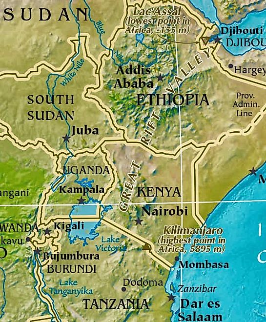
This is a slice of a larger topographical map that highlights the Great Rift Valley, a dramatic depression on the earth’s surface, approximately 4,000 miles (6,400 km) in length, extends from the Red Sea area near Jordan in the Middle East,, south to the African country of Mozambique. In essence, it’s a series of geological faults caused by huge volcanic eruptions centuries back, that subsequently created what we now call the Ethiopian Highlands, and a series of perpendicular cliffs, mountain ridges, rugged valleys and very deep lakes along its entire length. Many of Africa’s highest mountains front the Rift Valley, including Mount Kilimanjaro,Mount Kenya and Mount Margherita.
For additional details on many of the landforms of Africa, this page will help
Interesting Facts About Africa
Two of Africa’s most interesting geographical features are the Nile River System and Sahara Desert; both impressive in so many ways.
Nile River System: The Nile is a north-flowing river considered the longest river in the world at 6,650 km (4,130 mi) long. It is shared by and benefits eleven countries. The White Nile and Blue Nile are its major tributaries. The White Nile is longer and rises in the Great Lakes region of central Africa, flowing north from Tanzania to South Sudan. The Blue Nile is the source of most of the water and both rivers join near Khartoum, Sudan The northern section of the river flows almost entirely through desert, from Sudan into Egypt. The Nile ends in a large delta that empties into the Mediterranean Sea.
Sahara Desert: It’s the world’s hottest desert, the third largest desert after Antarctica and the Arctic, and almost as large as China. Covering almost one-third of the continent, the Sahara is the largest hot desert in the world at approximately 3,500,000 sq. miles (9,065,000 sq. km) in total size. Topography includes areas of rock-strewn plains, rolling sand dunes and numerous sand seas. It ranges in elevation from 100 ft. below sea level, to peaks in the Ahaggar and Tibesti Mountains, that exceed 11,000 ft. (3,350m). Regional deserts include the Libyan, Nubian and the Western desert of Egypt, just to the west of the Nile. Almost completely without rainfall, a few underground rivers flow from the Atlas Mountains, helping to irrigate isolated oases. In the east, the waters of the Nile help fertilize smaller parts of the landscape.